Arc Dome (11773') LVMC Trip
In the Toiyabe Range, NNW of Tonopah, NV
H.W. Stockman
Oct 2, 2004 |
We had a bit of weather. October at 11000 feet -- who woulda thunk it? As we climbed the last ridge before the Arc Dome col, the snowfall intensified, and the thunder increased. We aren't supposed to continue hiking in deteriorating weather; but I convinced myself that the weather could be getting better for all we knew (you know, the glass is half-full…before it gets struck by lightning). The Siberian and I were both brought up in miserable weather (I grew up in the wet and cold Adirondacks), so we continued to the top; the others wisely turned around before the whiteout socked in. However, I was nattily dressed for the occasion.
We actually heard no thunder after we started up Arc Dome, and ironically, our extra time on the peak allowed us to miss the cold rain that drenched those down below. I reasoned that the lightning was mainly at lower elevations, where the snow had a surplus of electrons at the cloud bottoms (in fact, when we descended below the clouds, we saw a tree that had been struck by lightning). On the summit, I suggested that there was a tendency to overstate lightning deaths. Nice theory; but on top of the peak, my cell phone began to crackle and buzz**, so we beat a hasty retreat.
Click on any small image to see a larger picture. (Cliquez sur une petite image pour voir la grande image correspondante.) Order is essentially chronological. Even the large images are reduced in size to 20% the number of pixels in the originals. Contact me if you want the full-sized images. To save a large image under Windows, 1) click on the corresponding small image; 2) when the large image appears (fully), right-click on the image and choose "Save Picture As..." on the menu. Be sure to note where you saved the image!
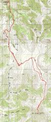
GPS trace |
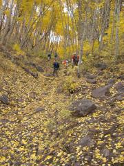
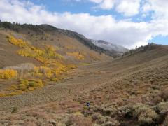
We all tried to wear bright colors, as hunting season was on -- and for the most part, we blended in with the aspens. |
Xoward and Luba. |
|
|
|
|
|
|
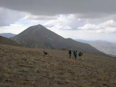
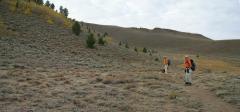
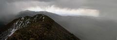
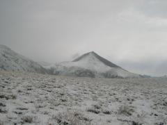
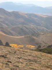
Arc Dome to the SSE -- still clear! |
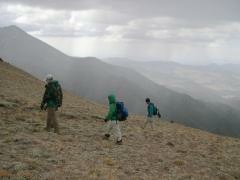
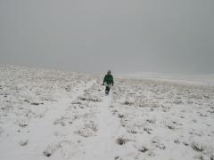
Hmmm, snow showers… |
|
|
|
|
|
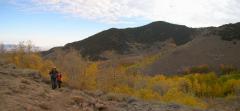
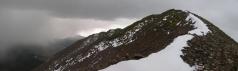
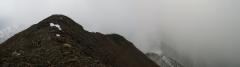
View ~ N from about 11600' on Arc Dome. |
There was a thick cornice on the NE side of the peak, with several feet of snow; so there must have been an intense snowfall in prior weeks. |
From the top, view ~S |
|
|
|
|
|
From the top, view ~NNE. |
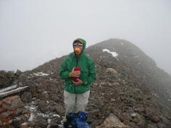
Self-portrait and cerebellum check on top. My pack had a great deal of warm dry clothes; I just wasn't cold. |
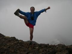
Luba reprises the Luau pose. |
|
|
|
|
|
Luba and I didn't grouse about the weather; but there is a complainer in every group. I suspect I have seen this fellow before. |
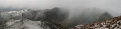
Arc Dome -- more snow than before. The whiteout lifts momentarily. |
At last. we're back to the road, and can put away the GPS. |
|
|
As we dropped to treeline, we saw a smoldering tree-- apparently a victim of a lightning strike. |
|
|
|
|
|
|
|
|
|
|
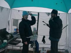
Sunday morn -- too much coffee, way too much. Kim tells Josh to hold his tong. |
|
|
|
|
|
|
To get to the trailhead at Columbine Campground, go a few miles W of Tonopah, and take the signed Gabbs-Poline Road north, then turn right on the unmarked State Road 21. Follow 21 N over to the intersection just south of the school, and turn right and travel SE on FS Road 119. More detailed instructions are at the bottom of this page You may contact me for more info at:
hwstock AT alum dot mit dot edu
OR download this GPS file in gpx format, which can be viewed with many mapping programs (such as ExpertGPS).
NOTE the gpx file is relative to the WGS84 datum; you must set your mapping software or GPS to this datum to make sense of the coordinates. The author takes no responsibility for the accuracy of the information in this gpx file; use it at your own risk.
=============
On Lightning Deaths in The Mountains
When I climbed Long's Peak in 1971, at the tender age of 16, the rangers warned me over and over to watch out for lightning. There was relatively little warning about falls, even though, back in those days, one typically ascended by the cable route on the North Face. I left with the impression that lightning was far and away the biggest cause of death; afternoon thunderstorms in the Long's area are definitely frightening, so I was easily convinced.
A few weeks ago, I came across this note on USENET:
"I saw a detailed listing of the first 54 recorded deaths on Longs Peak between 1881 and 2000 in the the recent book: "Longs Peak: The Story of Colorado's Favorite Fourteener." The causes break down into:
falls 34
hypothermia 8 (including recent one)
heart attacks 5
lightning 3
suicide 2
gunshot, rock fall, unknown 1 each"
It is notable that many falls were "on protection," yet above-timberline hikers (those presumed most prone to lightning) far outnumber rock climbers. Nonetheless, falling deaths outnumber lightning deaths by more than 10 to 1. Not that I suggest you should be cavalier about lightning; but the best plan for lightning safety, is not to venture out when there is a chance of a storm, period. If you can hear thunder, you are within striking distance. In Colorado as a whole, lightning deaths are high, and are almost entirely restricted to people who are oudoors -- in open fields, boating, standing under trees, and of course, on mountains. Certainly some locations are worse than others in a storm, but most people are simply "outside" when they are struck. If you think that it is enough to descend to lower elevations when you hear thunder, you are living under a substantial deception. Perhaps even more telling, is this breakdown of Utah lightning deaths.
This URL sums it up:
"Lightning-knowledgeable people use words like "capricious," "random," "unpredictable," and "erratic" when describing the way the bolts behave. They also acknowledge that when you're outdoors, there's no absolutely safe place to be. You'll be at risk regardless of your location. But we all accept a certain level of risk when venturing into the wilderness. The best thing to do is face up to the possibilities of what can go wrong, prepare as best you can with knowledge and information, stay aware of weather conditions, and if the worst-case scenario does unfold, head to safety."
**I've since done a lot of thinking about several of the electrical "signs" I felt on the peak. For example, I thought I felt the hair stand up on my right hand. However, I don't think that was any sort of charging effect; the hair on my head and my left hand suffered no such phenomenon. Furthermore, I often feel a tingling, localized on my right hand, when I plunge into fight-or-flight, so I now think that what I felt was psychosomatic.
I also head a buzzing from either my cellphone or GPS, just before I noticed the "hair standing on end" effect; in fact, that was the experience that put me into fight-or-flight mode. My GPS is always powered-up for such a trip (since I am tracking), but I thought my cellphone was powered off. However, most cellphones are never truly "off" as long as the batteries are loaded; furthermore, mine has annoying buttons on the side, with which I accidentally power the phone when I jam it in my pack. I actually took the phone out as we descended, and pressed the external off button -- by that time, I heard no more crackling, for whatever reason. I couldn't localize the crackling on top, to determine if the noise was coming from either the cellphone or GPS. Both devices have speakers and antennae, which are very sensitive to non-linear potentials.
Since youth, I have heard about "hair-standing-on-end" as a sign of imminent lightning strikes. Actually, people who survive lightning strikes will typically say that they felt nothing, and had absolutely no warning. For 16 years I lived in New Mexico, which as a state has the highest per capita lightning death rate (yet gets about 20% the precipitation; most of the strikes are in a corridor up the middle of the state). Every year in NM, we would hear of lightning deaths; typically the people were just standing outside in a schoolyard or other innocuous place, sometimes even in sunshine, while it was raining miles away.
===========
Road log:
First check out these maps:
http://www.herronweb.com/cgnes/frames/counties/nv/nye/columbine.html
http://www.fs.fed.us/r4/htnf/maps/austin/austin1CSWmap.jpg
http://www.fs.fed.us/r4/htnf/maps/austin/austin1SWmap.jpg
Here are some mileages measured off the map, NOT my odometer:
Travel N on i95 to Tonopah. From the intersection of Rte 6 and i95, continue
NW on i95 5.1 to 5.2 miles to the signed Gabbs-Poline Road on the right (N side).
SET YOUR ODOMETER TO ZERO.
Take the Gabbs-Poline Road, which is initially paved. At 12.1 miles, the road forks,
with paved road on both the right and left; TAKE THE LEFT FORK. The road soon
becomes a good gravel road. At 31.3 miles, turn RIGHT onto the
unmarked state rte 21 (also called FS 018). There is a sign on the left (W) side of
the Gabbs-Poline road at this turn, but as of 10-3-04,
the sign was on the ground and not too easy to see. You want to head
toward Cloverdale Summit or the Rees River Administrative Site.
At 36.7 miles, take the right (better) fork. Around 65 miles
(very roughly), the road is once more tarmac.
At 68.0 miles, the signed Ione road comes in from the left; TURN RIGHT,
and pass just south of the schoolhouse (for Yomba Indian Reservation).
You are now about 10 miles from Columbine campground. Initially travel
E till turning ~SE at 68.4 miles.
There is a maze of roads on the sides of the main road,
so look for and follow the signs for FS 119 and Stewart Creek and Columbine Campground, and generally travel SE to SSE.
You will make at least one shallow stream crossing on the way to Columbine Campground.
If you keep to the "main," better gravel road, you will generally be on the right track.
Supposedly, there is a Ranger station just NE of the Yomba school, so they may be able to help
if you get really lost.
The road was certainly 2WD for the vast majority of the way. The only place you might
want a higher-clearance vehicle would be the one stream crossing -- but if you take
it slowly, you should be OK in a 2WD.