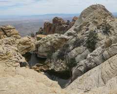
 A view of West Monument, the whitish peak at R. This is a truly striking peak, with water-filled tinajas in the late winter. View E. |
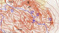 Here's how BW denoted the peaks. In 2008 we traversed over the ridge, starting at Black Velvet Canyon parking; that's the blue track. |
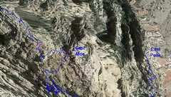 Google Earth illustrates the deep ravine just W of "East Monument;" this topography is not resolved on the topo map. Same track as in previous photo. |
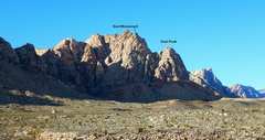
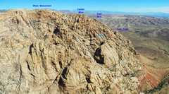 This view shows the ridge from the SW (Black Velvet Peak). Center Monument's east end blocks a complete view of the ravine between it and East Monument. |
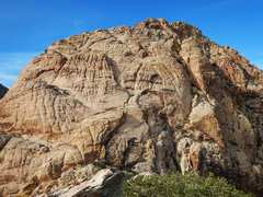
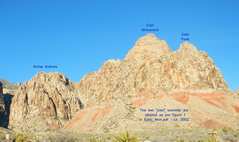 BW's East Monument is quite striking when viewed from the Black Velvet parking; this image reproduces the names (without copyright violation!) of Photo 1 in BW's guide. At the parking lot, the higher Center Monument is blocked from view by the lower summit. |
 This is a view N from Mud Springs. |
 Here's a view N from just below East Peak. There is a sharp drop of about 200' to the L, in the gully between East Peak and the rest of the ridge. |
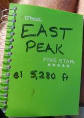 The new register on East Peak, placed in 2012. The elevation is probably closer to 5340', both from gps and topo map. |
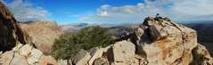
 This is a view W toward "East Monument," from East Peak. |
(From East_Mon.pdf: on BW's HikingLasVegas.com site:
"Note: East Peak and East Monument are two different peaks. [...] Once through the chute,
head NE and scramble up the sandstone to the ridge. There’s a great view of East Peak, which lies almost 500 feet
below you! [...] Continue west to the triangular black-faced rock in Photo 11. Just before the black-faced
rock stands East Monument Peak. [...] We placed a cairn at the peak in May of 2000. Unfortunately,
there’s no sign-in book, yet. From the peak you can see the problem Center Monument Peak poses."
The date stamp embedded in this pdf is December, 2001.)
| Now here's the rub. Rock climbers generally refer to the area around BW's "East Peak" as "Monument;" this naming goes back to the 1970s at least, and is illustrated on p 35 of Jerry Handren's Red Rock Climbing Guide. | 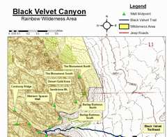 This is the official BLM map of climbing routes in the area (6-22-07 document). One "Monument" climbing area (Desert Gold) is arguably on the edge of East Monument; but the other two are on the E side of "East Peak." There is a well-used trail to the base of the "Monument South" climbing area. | BW created the "52 Peak Club" in 2011, and since then, hundreds of people have been to BW's "East Peak," so the name is unlikely to go away. Just know that when you discuss "Monument" with rock climbers, they may have a different opinion of where it is. |